Map services – tool for enhancing data availability
Publicly data used for planning against environmental problems

CHALLENGE DESCRIPTION In Sweden there is a lot of data publicly available, which could be used for planning measures against different environmental problems related to water. There are several issues concerning how to make this information easily accessible for those who are planning measures, and who eventually will be implementing them.
The work with water related environmental problems in Sweden is generally based on the needs defined by the Water Framework Directive (2000/60/EG). Which states that the ecological, chemical and quantitative status must be improved and maintained for future generations. This means that all surface and subsurface waterbodies need to be monitored and classified according to the directive, generating a lot of information.
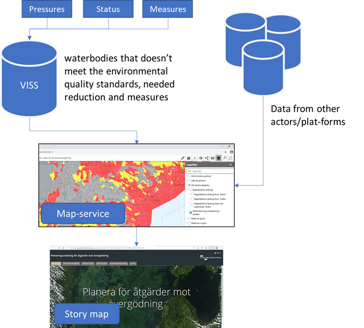
Sweden has a system for storing and sharing this information with the public and other stakeholders. The system is called Water Information System Sweden (WISS). The system is a web-based database where you can access information about all the waterbodies in Sweden (including everything from ecological, chemical and quantitative status to information about significant pressures and suggested measures).
The information in WISS is the basis for identifying where there are issues, e.g. waterbodies that doesn’t meet the environmental quality standards, and to some extent information about different suggested measures. The information is however on an overall level (per waterbody) and is not fully sufficient for planning measures on a finer scale. However, it is important to start from this overall level since the budget for measures is limited and it is important to implement them where they are needed the most. Planning on a local level also requires more detailed and local data. Such data is available for stakeholders but are often spread between different actors. Hence its hard to get a good overview of what kind of data that is available on a national scale. Regarding eutrophication, the Regional Water Authorities therefore has developed a solution for collecting and making data available on a common platform together with the information from WISS.

DESCRIPTION OF THE SOLUTION To make data available for planning measures against eutrophication, the Swedish Water authority has developed a web-based platform (map service). The platform consists of several map layers, based on information from WISS as well as information from other authorities in Sweden, including e.g. the Swedish Board of Agriculture and the County Administrative Boards. The GIS information in the map service is grouped into six main categories:
- Administrative boundaries. Map layers showing administrative boundaries such as boundaries for municipalities and county administrative boards.
- The boundaries of water. Map layers showing boundaries associated with water such as waterbodies and their catchment areas.
- Waterbodies in need of measures. Map layers showing surface waterbodies that run the risk of not meeting the environmental quality standards as well as the needed reduction of phosphorus and nitrogen.
- Implemented measures. Map layers showing implemented measures associated with eutrophication.
- Available measures. Map layers showing suggestions on possible measures associated with eutrophication.
- Other available data. Maps showing other available data for planning measures against eutrophication. Including, phosphorus- and nitrogen loads per waterbody, areas with high or low risk for erosion, historical maps as well as soil textures and much more.
As a complement to the map service the Regional Water Authorities have also developed a so-called “story-map”, where it is possible to explore the different map-layers together with short descriptive texts. This will hopefully make it easier for less experienced stakeholders to familiarize themselves with the data.
To summarize, the platform contains an important overall level, which is based on the needs associated to the Water Framework Directive. It also includes complementary information that can be useful when planning measures against eutrophication.
The present information within the platform is limited to the needs defined by stakeholders (catchment officers, consultants, municipalities, county administrative bords and other national agencies) who have had the opportunity to point out their needs during workshops. The platform is intended to be updated continuously as new data is available. However, it is important to also limit the amount of data and what kind of data that is presented. Too much data can conflict with the clarity and overview but also the response time for the platform (the time it takes to load the information when viewing). Data with too high a resolution could also conflict with the General Data Protection Regulation (GDPR).

POSSIBILITY OF ADAPTING THE SOLUTION Overall, this solution could be applicable in other countries with similar problems (e.g. a lot of data that needs to be compiled and made available). Even if the data availability is low, a compilation of the current available data together with a mapping of future needs would be beneficial.
| Authors of the solution description: | Jan Petersson |
| State of implementation of the solution: | – |
Links
https://ext-geoportal.lansstyrelsen.se/standard/?appid=85131fe1a5c0443ca0b26e3f0a904c67